Day #4

After three days of biking, driving up mountains, and kayaking, I decided to spend my final day at Acadia National Park leisurely paddling around Jordan Pond. Jordan Pond is yet another glacially carved feature of Acadia: it was created during the last ice age by the Wisconsin Ice Sheet. Jordan Pond is more correctly classified as a tarn, or a glacially carved mountain lake, rather than a normal pond. It’s about 150 feet deep, and closed in by a moraine deposited on its south end by the glaciers that created it. To the north of Jordan Pond are two pink granite mountains known as the Bubbles; like Cadillac Mountain, the Bubbles were also worn down into less sharply peaked mountains during the last ice age, about 10,000 years ago. They are known as “roche mountonees”; because of how the glacial ice moved across them, on the side where the glacial ice moved upwards they are smooth and have a gentle incline, whereas on the downslope side of the Bubbles the land is jagged and has a fairly steep incline because of the materials the glacier took out of the rock as it traveled downslope.

Jordan Pond with the Bubbles in the background, picture from acadiamagic.com

Jordan Pond is an extremely pretty and calm pond to go paddling around. The water was very clear, and as I went around the pond for about two hours, I saw several different kinds of birds, including loons and chickadees, as well as some frogs and turtles. After I finished paddling around Jordan Pond, I decided to eat lunch at the Jordan Pond House before driving back to the airport to catch my flight home. The Pond House is one of the Park’s most popular attractions, and is the only dining facility in the entire park. The Jordan Pond House was first established in the 1870s; however, a major fire that burned much of Acadia National Park in 1979 also destroyed the Pond House and so it had to be rebuilt. At the Pond House, I enjoyed a light lunch of salad, popovers and tea, before heading back to the Blackwoods Campgorund to pack up my things. All in all, it was a nice way to end my trip.

Posted in Uncategorized | Leave a comment

Day #3

Somes Sound as seen from the air, photo from Google Images

On my third day at Acadia, I decided to head out to sea, and kayaked around Somes Sound. (Note that in real life I’ve never actually kayaked before, it just seemed like something that would be fun to do). Like many other features of Acadia National Park and Mount Desert Island, Somes Sound was created by repeated periods of glacial activity over the past two million years. Around 14,000 years ago massive glaciers left behind depositions of mud, rock, and sand (moraines) that enclosed the area where Somes Sound is today. When the ice sheets melted, this area filled with water and became a freshwater lake. The ocean eventually rose above the moraines and eroded them away, turning the lake into the saltwater body of water it is today. Somes Sound is sometimes called the only fjord on the North American Atlantic coast; however, from a technical standpoint this labeling is incorrect. According to the Maine Geological Survey, a fjord is a “long, narrow, glacially-eroded arm of the sea usually hundreds of meters deep, with steep rock cliffs and a shallow sill at its entrance to the ocean”. However, Somes Sound is much smaller than a typical fjord (like the fjords of Norway), and so it’s more accurate to call it a fjard rather than a fjord.

It was a really nice day out, so my trip around the Sound took only about four hours (on windy days it’s much more difficult to kayak in the ocean surrounding Mount Desert Island since the winds cause stronger currents and choppier waters). I got to see a variety of different wildlife, including some bald eagles and harbor seals. From the water, Acadia looked pristine and unaffected by pollution or any negative environmental factors. However, one of the most major environmental issues currently facing Acadia National Park is one that can’t be seen with the naked eye: mercury contamination. Studies

Harbor seals at Acadia National Park, photo from flickr.com

conducted by the National Park Service at Acadia show that some species of fish, amphibians, and tree swallows contain enough mercury to put them at risk of lowering their chances of survival; the levels of mercury in the organisms is also much higher than is healthy for human consumption. Most of the mercury in the park comes from atmospheric deposition from mercury emissions in industrialized areas to the south and west of the park. The higher the affected organism is on the food chain, the more mercury is likely to be present in its body; this is due to biomagnification of the mercury up the food chain. Currently the National Park Service is trying to develop ways to minimize the impacts of mercury currently present in the park’s wildlife while also trying to prevent even more mercury from being deposited into the park.

Posted in Uncategorized | Leave a comment

Day #2

On my second day at Acadia, in the morning I went to the Sieur de Monts Spring. This spring is closely linked to the early history of Acadia National Park. While Mount Desert Island has been occupied periodically since the early 1600s, the area was not established as a national park until 1919. During the 1800s, Mount Desert Island was first a thriving economic area for farmers, lumberjacks, and fishermen, and later a refuge for artists and journalists who came to the island to spend time in the island’s “tranquil beauty”. As more people came to visit the island, several hotels were built there, and soon Mount Desert Island became a thriving vacation spot. However, in 1901 Harvard president Charles Eliot worried that the creation of the portable sawmill would result in the destruction of Mount Desert Island’s natural beauty, and started a nonprofit organization for the preservation of the island. In 1916, 6,000 acres of land that Eliot’s friend George Dorr had acquired became the Siuer de Monts National Monument. The Siuer de Monts Spring had been set up in the area in 1909. In 1919 the park became Lafayette National Park–the first national park east of the Mississippi–and in 1929 the park was re-named Acadia National Park; it is the only national park in the United States to have all of its land donated to the government.

There’s a lot to do near Siuer de Monts Spring; the National Park Service calls this area “the heart of the park”. I first visited the Abbe Museum, which is dedicated to educating visitors about the culture and history of Maine’s native Americans. The Abbe Museum actually has two branches, one near the spring and a larger branch in downtown Bar Harbor, but I only visited the Siuer de Monts branch. Inside the museum, there was a series of four interesting dioramas that showed what life was like on Mount Desert Island before the arrival of Europeans.
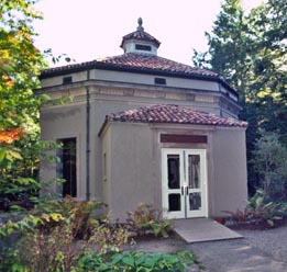
Abbe Museum, photo from Abbe Museum website

After I was finished at the Abbe Museum, I took a walk through the Wild Gardens of Acadia. While that may seem like a strange name for a small (less than one acre large) area of land in a sizable national park, the Wild Gardens of Acadia gives visitors a chance to walk through all of the park’s different plant communities in the same small area. The Gardens were extremely peaceful, and while I was there I got to do some birdwatching and saw many different specimens of the park’s birds. Acadia is known for being an extremely good park for birdwatching in; not only does it have common birds like ducks and blackbirds, but it is also the home of bald eagles and rare peregrine falcons.

On my drive back from the Siuer de Monts Spring area, I decided to drive up Cadillac Mountain. In order to get to the summit of the mountain, I had to drive up a very narrow, 3.5 mile long road, which was slightly nerve-wracking for me since I’m scared of heights. However, the drive was less terrifying, and significantly less spectacular than the view when I reached the top. At 1530 feet, Cadillac Mountain is not only the highest point in Acadia National Park, but also is the highest point on the entire North American Atlantic Coastline. The mountain was formed at about the same time that the rest of Mount Desert Island was formed, between 380 and 420 million years ago. As North America collided with the ancient Avalonian plate, it caused magma to move up through the crust, eventually bursting out into a gigantic magma bubble that cooled and became Cadillac granite. Cadillac granite is characterized by an abundance of feldspar, which gives it its signature pink color. This type of granite also contains quartz, hornblende, and biotite. Cadillac Mountain itself was carved after years of wearing down by glacial ice and exfoliation wore down its top until it was rounded, rather than pointy. The view from the top of the mountain was amazing: you could see clearly across the bay and could also see the nearby Porcupine Islands. It was definitely worth the drive on the way up.

View from Cadillac Mountain--photo from travelguideofamerica.com

Posted in Uncategorized | Leave a comment

Day #1

From October 3rd to October 6th, I visited Acadia National Park in Maine. Acadia is located about 46 miles south of Bangor, and the average latitude and longitude of the park is 44.3 degrees north, 66.3 degrees south. Upon arriving in Maine, I had to change the time on my watch and cell phone; Maine is in the Eastern Time Zone, which is one hour ahead of Central Time. In order to get to the park, I flew from Central Illinois Regional Airport in Bloomington to Bangor International Airport; after leaving the airport, I rented a car and drove on US-1A E until I arrived at Mount Desert Island, where most of Acadia National Park is located.

For the duration of my time in the park, I camped out at the Blackwoods Campground. Located near Bar Harbor, Blackwoods Campground is open year-round (albeit with limited capacity from December 1st to March 31st), and because I visited Acadia during one of their more busy times of the year, I had to make a reservation for a camping space before I got to the park. It can get pretty chilly in the park during October–average day temperatures are about 58 degrees Fahrenheit, and night temperatures average about 41 degrees Fahrenheit–so I made sure to pack a coat and a couple of blankets. While Acadia doesn’t get a ton of rain during October (according to the National Park Service, the park only receives about 4 inches of rain on average during the month), I still made sure to bring an umbrella and some rain boots, just in case.

There’s a lot of stuff to do at Acadia, and over the course of my trip I hope to do as much as I possibly can. Some of the features inside the park include dozens of hiking, biking, paddling, and kayaking areas, several large and spectacular ponds carved by glaciers, a museum, and a tea-house. One of the more unique aspects of Acadia National Park is that while the brunt of the park’s many features are located on Mount Desert Island, parts of the park are also located on the nearby Schoodic Peninsula and on several other smaller islands ringing Mount Desert Island. In order to get to these smaller islands, you have to take a mail-boat out and back.

After I arrived at Acadia and got settled in my campsite, I decided to do a little bit of leisurely biking. I drove my rental car over to the Parkman Mountain parking lot and from there biked along the Hadlock Brook Trail until I

Waterfall Bridge--photo from flickr.com

reached the Waterfall Bridge, which crosses over the brook right next to a forty-foot high granite waterfall. The trail was beautiful; besides passing the massive waterfall, it also went through a spruce forest and passed Upper Hadlock pond, where I stopped on the shore to eat a picnic dinner.

map from acadiamagic.com

Posted in Uncategorized | Leave a comment